


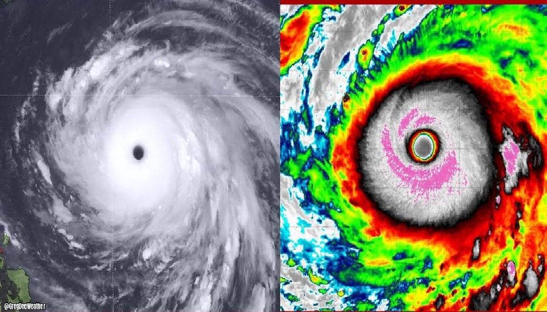
Storm Typhoon Champi is no longer a Guam story. It is now a Taiwan, Japan and shipping-lane story. But the storm has left a mark on the U.S. Pacific territories that residents there won’t forget soon.
A near miss that still did damage
Champi passed within 10 miles of the southern tip of Guam early on Oct. 17 as the equivalent of a Category 4 hurricane, and reached super typhoon status with sustained winds of 150 mph just after it moved past the island. The National Weather Service called the winds extremely dangerous and life-threatening, and a Guam forecaster described the storm as a very near miss.
The speed of the buildup caught even forecasters off guard. Champi went from a tropical storm to the equivalent of a Category 4 hurricane in under two days, and a weather service meteorologist in Guam said the rapid intensification outperformed expectations. The strongest winds hit southern Guam, where no sensors were available to record them, though gusts likely topped 100 mph.
AccuWeather reported that the storm ripped roofs off buildings and knocked down trees on the island. For a community that has been through a lot in a short time, that is a hard result. Champi is the third typhoon to affect the Northern Mariana Islands in six months, after Super Typhoon Sinlaku struck Saipan on April 14 and Super Typhoon Bavi made landfall on Rota on July 6.
Where Champi is headed
Once past the Marianas, the typhoon kept moving west-northwest across the Philippine Sea. Philippine forecasters said it would enter their area of responsibility on Oct. 20, where it would be called Rosal, and would turn northward after Oct. 21, with weakening expected to begin around Oct. 22 once it peaks.
The Japan Meteorological Agency painted a similar picture of a large, dangerous system. It forecast Champi reaching violent strength on Oct. 21, then passing near Japan’s Sakishima Islands between Oct. 23 and the morning of Oct. 24, with heavy rain, destructive winds and high waves possible there. AccuWeather expects heavy rain and strong winds in Taiwan from Thursday night, Oct. 22, into Saturday, along with coastal flooding in the eastern part of the island.
After Taiwan, the forecast gets murkier. The Hong Kong Observatory said the city is unlikely to be hit directly. It noted that several AI weather models show Champi making a sharp northward turn near eastern Taiwan, with some then carrying it across Japan or near Tokyo around Oct. 25 and 26. Those are model outputs, not official forecasts, and track uncertainty grows the further out you look. Anyone with plans in Taiwan, Okinawa or Japan should follow their national weather agency rather than social media maps.
Could Champi be the year’s strongest?
The Weather Network reported that Champi had a chance to become the world’s strongest tropical cyclone of 2026, which would require beating Hurricane Polo, the current record-holder. Whether it gets there is far from settled, and the storm appeared to ease back slightly after its Guam pass. That said, it’s far from the only monster this year.
Bavi: the track that ended on Rota
The most useful comparison is Super Typhoon Bavi. Forecasters spent days watching its track. A late forecast shift sent the storm slightly south, passing between Rota and Tinian rather than farther north. That small change had large consequences.
The weather service said all of Rota sat inside Bavi’s eye on July 6, with winds up to 180 mph. Rota’s mayor said most homes on the island were damaged or destroyed, and that its government buildings, airport and seaport were hit as well. Lawmakers reported no injuries or deaths in the first hours, which authorities credited partly to residents sheltering as warned.
After the Marianas, the Bavi track continued across the Pacific. Forecasters first expected it to cross Taiwan, but it shifted north and was projected to come ashore on China’s eastern coast between Fujian and Zhejiang provinces. The lesson for readers watching Champi is that a 50-mile wobble can decide who gets the worst of a storm.
Dolphin and the El Niño factor
Super Typhoon Dolphin followed in late July and early August. NASA reported it reached Category 5 strength on July 30 with 165 mph winds, going from a tropical storm to a super typhoon in just two days over very warm water with little wind shear. The Hong Kong Observatory noted that the strongest western Pacific storms on record were Tip in 1979 and Nancy in 1961, and said some models suggested Dolphin could approach historic extremes.
Dolphin later lashed Okinawa, injuring five people and cutting power to 14,000 buildings, and made landfall in eastern China on Aug. 9 after more than 1,000 flight cancellations, evacuations and a top-level alert.
Behind this busy season is a powerful climate pattern. One report said the Pacific is in a super El Niño phase, which does not necessarily produce more storms but helps turn individual ones into super typhoons. NOAA data shows an 81% chance of a very strong or super El Niño during October through December. If that holds, late-season storms like Champi may keep outperforming forecasts.
Uwan: a reminder from last year
Readers searching for Super Typhoon Uwan are often looking at last year’s storm, which is still instructive. Uwan is the Philippine name for Typhoon Fung-wong, which struck the Philippines and Taiwan in early November 2025. It made landfall in Dinalungan, Aurora, on the evening of Nov. 9, 2025. More than a million residents were evacuated. By Nov. 12, the Office of Civil Defense had put the death toll at 27. The storm names change from year to year, but the pattern of fast intensification and heavy flooding does not.
What to do now
If you are in Guam, the Northern Marianas or the U.S. military community in Okinawa, rely on official National Weather Service and base advisories. If you have family in Taiwan or Japan, expect disrupted flights and port closures over the next several days. Forecasters on every side of this storm have said the same thing: the track and intensity near closest approach could still change.